The Franz Josef Glacier was named by the German explorer Julius von Haast, who named it after the Austrian Emporer Franz Josef I. The Maori's call it Ka Roimata o Hinehukatere ('The tears of Hinehukatere'). Hinehukatere loved climbing mountains and persuaded her lover,
Wawe, to go with her. However, Wawe wasn't a very good climber, and an avalanche swept him to his death. Hinehuketere was broken-hearted and her many tears flowed down the mountain and formed the glacier.While this is a lovely story, I find the actual reason for there being a glacier more interesting.
The South Island of New Zealand is actually formed from two techtonic plates; the Indo-Australian plate to the west and the Pacific plate to the east. Where these two plates are colliding, at the Alpine Fault, huge mountains have been thrown up. These are the Southern Alps. It explains why there is so much earthquake activity in New Zealand, and why New Zealand gets about 3cm closer to Australia every year (much to the New Zealander's distress).
When evaporated water in the air moves up and over mountains, it gets colder, condenses, and falls to the ground as snow. Because New Zealand lies in the Roaring Forties, as well as the El-Nino weather pattern, it gets a lot of warm air carrying an awful lot of water hitting the West Coast. As a result Franz Josef gets approximately three times as much snow as other glaciers worldwide.
When snow falls on the top of the mountain, the pressure and temperature causes it to freeze into blue ice, and hence creates a glacier. The glacier originally began in an ice age, and extended all the way out to the Tasmanian Sea on the coast 15,000 years ago. Nowadays the terminal face (end bit of the glacier) is about 19km away from the sea, though the glacier is advancing and retreating all the time. The movement of the glacier depends on the balance between the amount of snow falling on the neve (the top) and the amount of meltwater coming from the terminal face. At the moment Franz Joseph is advancing, at times up to 70cm a day - phenomenal speed in glacier terms. It also flows 10 times faster than most glaciers.
Another unusal aspect about Franz Josef is it is one of only three glaciers in the world to extend into a rainforest (one of the others, Fox Glacier, is just down the road, and the other is in South America).
Glaciers tend to be rather cold, funnily enough, so before we were allowed to set off on our day we were given lots of special clothes by the glacier guides. This included: rain jacket, waterproof trousers, hat, gloves, special boots, and a bumbag containing crampons (slip-on devices with big metal points to provide traction when walking on the ice).
After suiting up we got a bus to the rainforest, and walked half an hour through to the glacier. This is what our first look at it was like:

From where I was stood, the terminal face looked to be about 200-300m away. However, it is very difficult to appreciate any sense of scale when faced with something so massive, and it was actually a 2.3km walk from there to the start of the glacier.
However, the start of the glacier didn't mean the start of walking on ice. Oh no. First we had a half an hour climb up a massive pile of rocks called the terminal moraine.
Moraine is an accumulation of rocks created by glacier activity. As a glacier flows through a valley it chips off rocks and boulders from the bottom and sides of the valley and, like a big conveyor belt, some of these rocks end up at the front of the glacier, being pushed down the valley. This is called terminal moraine. It can be used to see where a glacier has been in the past - indeed we saw some giant piles of rocks some kilometres away from the current terminal face.
There are many other types of moraine. Medial moraine lies on top the glacier, like so (in the foreground):

Lateral moraine is found on either side of the glacier, and can result in huge boulders ending up at the tops of mountains and things, where they have no business being. It can also result in boulders impacted into the sides of the valley, like these two we saw during our time on the ice:

After finally clambering up the terminal moraine we fitted our crampons onto our boots and took our first tentative steps on the ice. Turns out, there is no need to be tentative - the crampons do their job quite effectively and as long as you put your feet down heavily you will not slip at all.
The climb up the glacier was at times quite hard. First thing in the morning (and it really is first thing - our day started at 8:30am and they had already done this) the glacier guides go out onto the ice with chainsaws and create the path for us to climb. They have to do this every day, because within the space of a few hours any steps or paths created will have either melted away or broken up into huge crevasses as the glacier flows down the valley (currently flowing at about 3m per day - super speedy). Even as we were climbing they had to revise the path constantly because it changed so fast. Here is our glacier guide creating a step with his pick-axe:


It was surprising how blue it was. It was also surprising how wet the glacier was. I know that sounds weird, but I had envisaged glaciers as just big blocks of solid ice. However the water is constantly melting, and all over the glacier there were little streams and waterfalls within the glacier itself, running in tunnels beneath our feet.
After a good few hours squeezing through tight crevasses and hauling ourselves up steep steps carved into the ice, we stopped for lunch. Here is a diagram of the glacier:

Yep, after four hours of climbing, that was how far we'd travelled. Not very far at all.
After lunch the guides took us to two features in the ice. The first was a big bridge of ice, that was unusual in that it had been around for a whole month. Normally something like that would only last a few days. Unfortunately, however, this meant we couldn't walk under it as at any moment it was going to collapse, and hundreds of tons of ice would fall down. Our guide said if it didn't fall within the next couple of days they may have to chop it down because it will only become more hazardous.
Unfortunately our guide took that picture, and while may be handy with a pick-axe, he's not very good at photography.

The climb up the glacier was at times quite hard. First thing in the morning (and it really is first thing - our day started at 8:30am and they had already done this) the glacier guides go out onto the ice with chainsaws and create the path for us to climb. They have to do this every day, because within the space of a few hours any steps or paths created will have either melted away or broken up into huge crevasses as the glacier flows down the valley (currently flowing at about 3m per day - super speedy). Even as we were climbing they had to revise the path constantly because it changed so fast. Here is our glacier guide creating a step with his pick-axe:


After a good few hours squeezing through tight crevasses and hauling ourselves up steep steps carved into the ice, we stopped for lunch. Here is a diagram of the glacier:

Yep, after four hours of climbing, that was how far we'd travelled. Not very far at all.
After lunch the guides took us to two features in the ice. The first was a big bridge of ice, that was unusual in that it had been around for a whole month. Normally something like that would only last a few days. Unfortunately, however, this meant we couldn't walk under it as at any moment it was going to collapse, and hundreds of tons of ice would fall down. Our guide said if it didn't fall within the next couple of days they may have to chop it down because it will only become more hazardous.
Unfortunately our guide took that picture, and while may be handy with a pick-axe, he's not very good at photography.
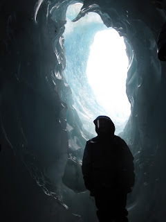
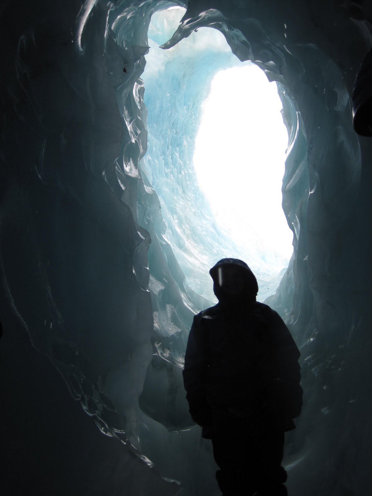
After the ice bridge we went to an ice cave that had appeared overnight, then set off back down the glacier. This took much less time than going up, and some of it felt a bit more like deliberate falling than walking. At one point DrE broke both her crampons, so I got to play around with the guide's pick-axe while he fixed them:

Hi ho, hi ho, i's off to work we go, with a shovel and a pick-axe.
ReplyDelete